The past couple of years have been fairly busy around the Holiday Season as we thankfully try to keep up. Many of our creations are shipped to clients across the oceans. Prospective customers also ask if we ship to their country. The thought occurred to me one day that it would be good to have a visual representation of where our creations have journeyed across the planet over these many years. A list is good and our Clients + Collectors page serves well, but an interactive globe showing the many locations would be perfect.
Many technologies were tried and some were a tad taxing on the user's CPUs/GPUs, so rejected. Finally found one that was light, responsive and user-friendly, so began modifying it to suit our needs. The initial markers were huge, however. With the density anticipated, especially in large cities, I had to come up with a way to substitute with something more in scale. Took a bit of sleuthing and some hacking the code but got it done.
Then came the question of which Earth map to wrap the globe with. The choice between centuries old cartography created by Giovanni Cassini and the view of our planet from space and a current geophysical map was just too difficult to make. Each of them have their good points and the user would also have their preference.
Answer: All Of Them, of course. (It's me. What'd you expect?)
The original globe loaded three maps and one could dissolve between them. This wasn't efficient, because manipulating three maps is essentially unnecessary and just drags the system down. So, I set out finding a way to allow loading maps on-demand; replacing the one current. This went through many iterations. All of the maps are served from tile servers, so as you rotate the globe and/or zoom in, higher resolution tiles are requested. Not to make a pun, but I think we now have the best of all worlds:
There are seven maps wrapped upon the globe. Each is available for view by selection in the control panel and are zoomable to varying degree, depending upon the source data resolution.


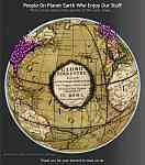
- The top level is Giovanni Maria Cassini's 1790 Map of the continents and oceans between them and shows the routes of three of Captain Cook's Voyages.
- "The Blue Marble" - A view of Earth from space assembled from spacecraft remote sensing data. This gives us the land and oceans, as they would appear without any clouds.
- "The Black Marble" - A view of Earth as seen from orbit on the local nightside of the planet, with terrestrial lights aglow.
- "Natural Earth" - A photographic view of Earth from space with clouds.
- Terrain Map - Assembled from spacecraft remote sensing and topographic data, this gives us land elevation, ocean bathymetric depth and textures.
- Terrain Map with Labels combines the Terrain Map with the Road Map.
- Road Map is current cartography data. It is zoomable to reveal geographic boundaries, cities, towns and individual streets. Depending upon your hardware and connection, the higher resolution tiles may take a bit of time to update for clarity and smooth rotation.
Adding the latitude/longitude of each location to place a marker proved to be daunting at first but I developed a method that became fairly efficient. Still tedious, but it was good to see the markers accumulate and kept me going. Rather than enter each individual address, which would be something of an invasion of privacy, I found that either just entering the town if small or postcode if a larger city, resulted in a rich dispersion that prevented markers from sitting directly on top of each other. Took a while, but well worth it.
 We hereby present for your amusement (and our amazement):
The Spherical Magic Clients, Collectors + Patrons Globe.
Tags: art and science, code, computer, perception, perspective, programming, technology
Short URL for this post:


 RSS - Posts